Hiking to the Wall of the Ancients Rock Art Panel and Warrior's Wall Ruin In Sedona

The trail into Loy Canyon is rarely used, probably because visitors to Sedona read the description and see that it is almost 10 miles roundtrip, so doing the full trail up to the rim is rated as difficult, and Sedona is full of shorter, easier trails that are closer to town. They don’t know what they’re missing.
The ancient Sinagua, ancestors of the modern Hopi, certainly knew a good thing when they saw it, and they chose the area around Loy Butte to build the largest cliff dwellings in all of Red Rock Country. They also held ceremony here, creating the single most impressive rock art panel in the entire Verde Valley.

Kachina Mask at Wall of the Ancients Rock Art Panel
While many New Age believers in Sedona speak of Bell Rock and Cathedral Rock as ancient sacred sites, but these formations did not hold any special attraction for the Sinagua. For them, the real sacred site was 10 miles west of town in Loy Canyon. The ruins are among the most photogenic in Sedona. The famous "Warrior's Wall" is an unforgettable defensive structure built on a narrow ledge to protect a valuable water source. Here one or two warriors could have held off a hundred.
The "Wall of the Ancients" rock art panel across the canyon spans almost 100 yards. It contains images from every culture to ever occupy the Verde Valley. Tread lightly here, for this area is sacred to the Hopi. It is also monitored by hidden cameras and site stewards.
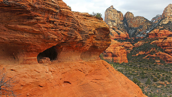
Warrior's Wall Cliff Dwelling

Wall of the Ancients Rock Art Panel
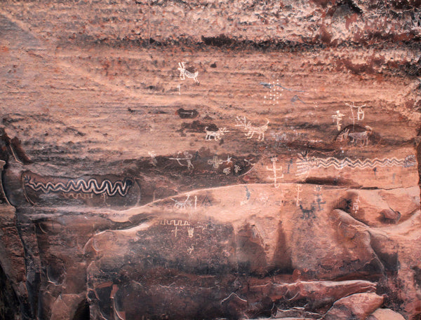
Wall of the Ancients Rock Art Panel
GPS FOR TRAILHEAD
34.932125 -111.925036
GPS FOR THE WARRIOR'S WALL CLIFF DWELLINGS
34.932125 -111.925036
GPS FOR THE WARRIOR'S WALL CLIFF DWELLINGS
34.946531 -111.926906
GPS FOR WALL OF THE ANCIENTS ROCK ART PANEL
34.942056 -111.917844
DISTANCE ONE WAY
1 mile to the rock art
1.26 miles to the ruins
5 miles to the rim
ELEVATION GAIN
150 ft to the rock art
450 ft to the ruins
1680 ft to the rim
ESTIMATED HIKING TIME
2 hours for rock art panel
3 hours for the ruins
6 hours for the rim
BEST TIME TO GO
All year for ruins & rock art
Sept - May for the full trail to the rim
PET FRIENDLY
Yes for the system trail only. They must be leashed at all times. Please pick up after them and pack it out. No for ruins and rock art! Please do not bring your pet to archaeological sites.
PET FRIENDLY
Yes for the system trail only. They must be leashed at all times. Please pick up after them and pack it out. No for ruins and rock art! Please do not bring your pet to archaeological sites.
Want to Find More Local Secrets? Download the our Hiking Guide to Sedona's Fabulous Social Trails!
Finding the Trail
Take Dry Creek Road from West Sedona. Turn left on Boynton Canyon Rd, then left again on Boynton Pass Road. There are stop signs at each of these intersections. Boynton Pass Road soon turns to dirt. Continue on Boynton Pass and follow the signs to Honanki and Palatki. This will turn into Forest Road #525. The dirt road is rough but passable to a 2 wheel drive passenger vehicle if you drive cautiously. The parking area for Loy Canyon has a sign, and the trailhead is directly across the road.
The map below shows Wall of the Ancients rock art panel on the right side of Loy Canyon (marked with a red triangle) and the Warrior's Wall cliff dwellings on the left side (marked with a yellow sun symbol). It also shows the location of Honanki Heritage Site and a cliff dwelling on top of Loy Butte.

The first part of the trail works its way through the Hancock Ranch, outlined in purple on the map above, which is privately owned. DO NOT GET OFF THE SYSTEM TRAIL WHILE CROSSING PRIVATE PROPERTY! You will be trespassing. It's not necessary to trespass in order to visit either of these locations. As signs will indicate, the system trail has been given permission to cross the ranch.
Once the trail drops down next to the (normally dry) main channel of Loy Canyon, the ranch house will be visible on the left. You're almost there, but not yet. STAY ON THE SYSTEM TRAIL!
The first landmark you need to find is approximately .7 miles from the parking area, where the system trail crosses dry (normally) creek that has step cut in the opposite bank. This normally dry creek crossing is the critical landmark (GPS 34.939956, -111.824589) that let's you know you are now on public land and free to move about the canyon.
You'll see a no trespassing sign on the right side just before you reach this critical landmark. The right turn to Wall of the Ancients is just after the NO TRESPASSING sign and just before the creek crossing with the steps cut in. The destination GPS for Wall of the Ancients is 34.94151, -111.91910.
The turnoff to to the Warrior's Wall is .3 miles farther beyond the creek crossing with the steps. You'll see two large alcoves on the left side of the trail. The ruins are just around the corner from these two alcoves, as shown in the photo below.
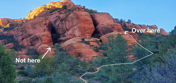
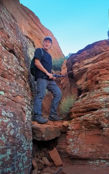
"Over here" in the photo above will lead you to a short Class 1 scramble, shown in the photo below. This means you'll have to use your hands, but there isn't much possibility of a serious fall. The critical left turn to the Warriors Wall is at GPS 34.944761, -111.924436.
When it comes to the final approach to the Warriors Wall the GPS track we have provided is approximate. The destination GPS for the Warriors Wall is 34.94671, -111.92714, which again is our best approximation.
Good luck in finding these beautiful places! If you have questions, feel free to email us or direct message us on Instagram. We'd love to see your photos, so tag us if you find it!
Written by Ed Preston and AP Schlosser