Top 10 Secret Hikes In Sedona You've Probably Never Heard of
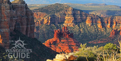
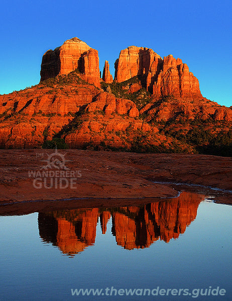
Sedona Arizona has been widely acclaimed as “the most beautiful place in America” for good reason. The visual appeal of iconic formations like Cathedral Rock and Bell Rock have attracted photographers from all over the world since the 1950’s. Relentless promotion of the area as a spiritual destination began in the early 1980’s and visitation steadily increased every year since, to the point that many hiking trails have now become crowded.
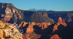
Yet hidden in this rugged landscape are dozens of secret gems known only to a small handful of locals, where red rock solitude still exists alongside jaw dropping photo opportunities. You may have seen photos of these locations posted on social media, with a string of comments below asking “where is that?” The question always goes unanswered, since the locals who are privileged to know enjoy the special status that comes from having insider knowledge. Now, for the first time, a professional guide with 40 years of experience hiking the red rocks finally breaks the code of silence to reveal his list of the top 10 “secret” hikes that the locals won’t tell you about.
If you want to hike any of these locations we have made it easy by creating a printable map that you can take along, as well as a GPX file that you can download and install on virtually any GPS device. That way you can track yourself as you hike, significantly reducing the chance that you will get lost along the way. Without further ado and in no particular order, let’s take a look at some eye candy!
#1 The Subway

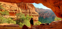
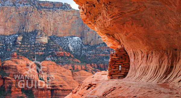
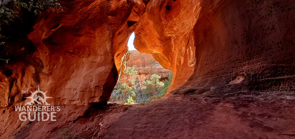
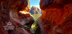
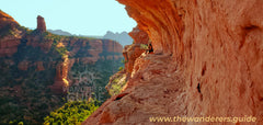
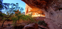
Located just a half mile off one of the busiest trails in Sedona, The Subway is one of the most photogenic locations in . It was Red Rock Country. It was kept secret by local elitists for so long that it was usually referred to online as "Secret Cave" and the only way for visitors to find it was to beg one of the locals for help in a series of private messages, or hire one to take you there illegally. That is until the Wanderer’s Guide got tired of answering so many individual requests and decided to reveal its location in November of 2020.
We took a lot of heat for that decision, but so far we've been proven right. Hundreds of people have been able to enjoy this incredible spot without destroying it or getting themselves killed (hint: it's really NOT very dangerous). The Subway is now becoming a popular destination, since the hike is rated as easy and the view is sublime. As an added bonus there’s a beautiful Sinagua ruin just around the corner. As with all the archaeological sites in the Southwest, please do not bring your pet and leave the site exactly as you found it.

#2. The Dreamspeaker Cave
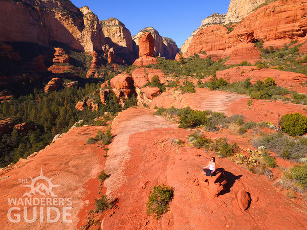
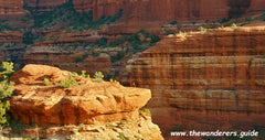
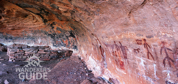
A lot of hikers who found the Subway after we initially revealed it's location probably did not maximize the experience during their hike, and that's because we deliberately held something back knowing full well bigger websites would sweep in quickly. What we failed to mention is that the Subway can easily be combined with a visit to the DreamSpeaker Cave nearby -- provided you know the right route to take. If the Subway is a home run by itself, then combining it with the Dream Speaker is a grand slam, and only those who have taken the time to fully explore the canyon would know this.
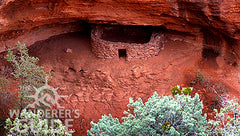
Replete with 360 degree view, towering cliffs and several large rock spires, the view from this ledge 400 ft above the canyon floor is arguably one of the top 10 most scenic spots in all of Sedona. It certainly gets our vote! Combine that with one of the best preserved cliff dwellings in the area and you'll definitely want to take some time to stroll around in the open slickrock. If there has been any rain recently you might even find several reflecting pools holding water, but even in dry conditions photographers will find plenty of inspiration at the Dream Speaker Cave.

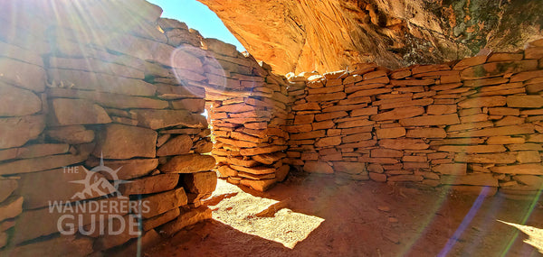
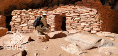
#3. The Warrior's Wall Ruins
Those looking for a moderate hike far from the maddening crowd will love the Warrior's Wall, a spectacular collection of picturesque cliff dwellings tucked away in a seldom visited red rock canyon. The drive out is a little rough, but it's easily passable to a passenger car, and the experience of solitude is well worth a little extra effort. Named for a defensive wall that was strategically placed on a narrow ledge, the Warrior's Wall has long been top destination reserved for locals only.
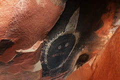
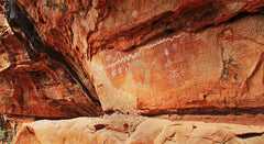
If it were just the ruins we would still recommend this hike, but there's more! The largest single rock art panel in all of Red Rock Country is right across the canyon, marking the ceremonial significance of this area to the ancient Sinagua. Over 100 yards long, the incredible array of images includes hundreds of pictographs and petroglyphs that date back thousands of years. Archaeologists believe every native culture that ever lived in the Verde Valley left their mark here. Many of the images will be immediately apparent, but stay awhile to let your eyes adjust and you'll begin to see even more. Look hard enough and you might even find the famous Kachina mask.
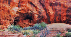
#4. The Kachina Tree Cave
Every professional photographer who did their research before coming to Sedona has asked us "do you know where the tree is?" This question always refers to the famous Kachina Tree Cave. If you catch the light streaming in just right (early in the morning) the images you bring back home will not only take your breath away, they'll also leave your friends on social media filled with envy. Just a half mile off one of the busiest trails in town, this hike is rated as moderate, although it does involve working your way through some brush.
Once again there are some bonus images along the way that most hikers don't even know about when they are starting the hike, including one that is very similar to the Subway. With just a little extra effort there are also some ancient cliff dwellings to explore, making the Kachina Tree one of the best overall hikes in Sedona.
Once again there are some bonus images along the way that most hikers don't even know about when they are starting the hike, including one that is very similar to the Subway. With just a little extra effort there are also some ancient cliff dwellings to explore, making the Kachina Tree one of the best overall hikes in Sedona.

#5. The Sunrise Ledge

Among the best kept secrets in Sedona, the social route to the Sunrise Ledge is rated as moderate, requiring nothing more than a detour of approximately a mile off one of the main system trails. Like many of the top 10 secret hikes, this one provides the adventurous visitor with multiple rewards -- solitude, big views, an ancient cliff dwelling, and the remains of a Prohibition Era moonshine still. The trail skirts a ledge 400 feet above the canyon below, bringing hikers to a spectacular overlook. Here the ledge widens a bit, then juts out into a sharp point known as the Stiletto.
Not that many people have ever seen the Stiletto, but everyone who does immediately wants to walk out to the point. All by itself this one view would warrant inclusion in this list, but the photo opportunities are just beginning. The Sunrise Ledge isn't visible from this overlook, but it's only about 50 feet away, directly below, and the route down is easy to find once you know to look for it.
#6. The Ice Cream Cone Cliff Dwellings
One of the most picturesque cliff dwellings in Sedona is the destination for our next secret hike: the Ice Cream Cone Ruins. The funny sounding name comes from a nearby landmark that looks just like -- you guessed it -- a soft serve ice cream cone! Located in a hidden valley hanging high in the canyon wall, the three room ruin is tucked behind another rock formation called "the Three Sisters." It's hard to imagine a more idyllic setting for ancient Sinagua farmers.
The structure is well preserved beneath a cathedral-like alcove, and even has a small rock art panel as well. The hike to the Ice Cream Cone is rated as moderate to difficult, but the 600 ft elevation gain on this trail means you'll enjoy plenty of solitude, and the passage behind the Three Sisters offers unforgettable views of the popular canyon below.
The structure is well preserved beneath a cathedral-like alcove, and even has a small rock art panel as well. The hike to the Ice Cream Cone is rated as moderate to difficult, but the 600 ft elevation gain on this trail means you'll enjoy plenty of solitude, and the passage behind the Three Sisters offers unforgettable views of the popular canyon below.
#7. The Lost Canyon Loop
Like the Ice Cream Cone cliff dwellings, this spectacular route leads to a well preserved archaeological site, but in this case there are three separate cliff dwellings. The first ruin is in a rare north facing alcove and has an amazing pictograph panel featuring the headless man of Hopi prophecy; the second has a kiva-like structure and appears to have been constructed to observe the winter solstice at sunrise; the last ruin is tucked deep at the bottom of Lost Canyon near a narrow passage to the ledge above. The arrangement of these three ruins and the north facing rock art panel indicate the ceremonial significance of this area.
The Lost Canyon Loop is rated as moderate and offers fantastic views of the entire Dry Creek Basin. There are actually three different versions of the Lost Canyon Loop, giving hikers the opportunity to adjust the length of the hike to suit their ability and time. A high clearance vehicle is required to hike this one.

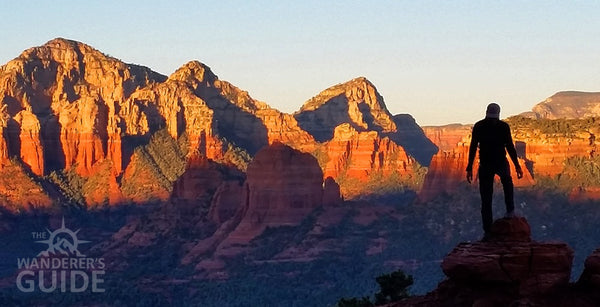
#8. The Stairway to Heaven
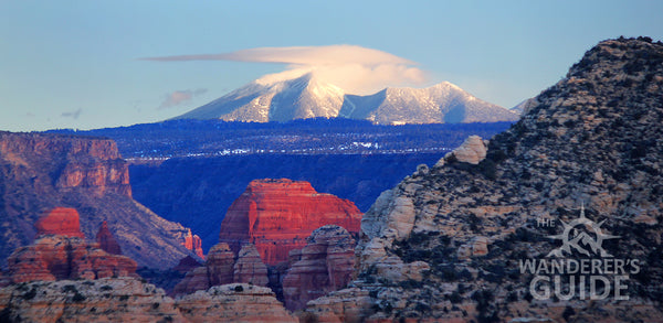
Imagine looking down on Bell Rock and up at the highest point in Arizona, at the same time! For photographers who want a more challenging hike with red rocks in the foreground and a snow covered peak in the back, the route we call Stairway to Heaven is the best place to find it. Few locals have ever done this route, so once you get past the crowds that cluster around Bell Rock, you're almost guaranteed to have it all to yourself. It's rated a strenuous, but the steep climb is actually fairly short.
The 360 degree view at the top is nothing short of magnificent! You'll be looking across Oak Creek Canyon all the way to the top of the San Francisco Peaks in Flagstaff, which are often covered with snow. From there you can explore the top of the ridge all the way to the summit of Gibraltar Butte.
#9. The Secret Slickrock Trail
Technically this is a designated system trail within the Coconino National Forest, so despite the name it's not really a secret anymore. We decided to include it in out list secret hikes because most people still don't know where it is. Of the trails listed here, Secret Slickrock is actually the easiest. It's a short walk from the parking area out to a broad area of open sandstone with an incredible view of Cathedral Rock. If it has rained recently there are two large pockets in the rock that hold water, creating perfect reflection pools. This is definitely one of the best places to capture a great sunset photo of Cathedral Rock.
#10. Trail of the Year
Sandwiched between two of the most popular trails in town, the route we call Trail of the Year is a narrow ridge of rock with yet another 360 degree view. We don't know if this route has a commonly used name, but when our little hiking group of Sedona veterans (all of whom have decades of experience hiking in the area) first stumbled out onto this ridge early one Saturday morning, we all agreed that it was one of our favorites. That's how we came to call it "Trail of the Year."
This route is rated as difficult, but only because there is a short, steep section to reach the top of the ridge. After reaching the top hiking along the knife-edge out to the end is relatively easy. Since very few people leave the popular trails below to come up here, you're almost guaranteed to have the view all to yourself. At sunrise and sunset the light on the surrounding cliffs is spectacular.
Hello – Thanks for advice! How do you get to the “trail of the year”? Appreciate any help you can provide. Love the website!
Thanks for sharing
Hello,
I do not see the printable map mentioned in the forward of this guide. Please email it or include the gps locations!
Thank you
These look great! I have been trying to figure out how to get up on top of the saddle between Boynton and Long Canyon. Does your guide have a trail up there? Thanks
We are traveling to Sedona next month and would like the map for The Top 10 Hikes in Sedona You’ve Never Heard Of. Can you let me know which maps I need tp order?