Southwest Colorado Cliff Dwellings - Hiking Trails & GPS Coordinates (Over 150 Sites Included)
The towers of Southwest Colorado inspire awe and wonder. Hovenweep National Monument is one of the least visited sites, mostly because visitors with little time tend to opt for Mesa Verde instead.
The Great Kiva at Chimney Rock is aligned to phases of the moon, and is the highest elevation archaeological sites in the Southwest.
The Great Kiva at Escalante Ruins
Engineer Peak is one of the most recognizable mountains in the Durango area.
Southwest Colorado Cliff Dwellings - Hiking Trails & GPS Coordinates (Over 150 Sites Included)
  • Load image into Gallery viewer, Southwest Colorado Cliff Dwellings - Hiking Trails & GPS Coordinates (Over 150 Sites Included)
  • Load image into Gallery viewer, Southwest Colorado Cliff Dwellings - Hiking Trails & GPS Coordinates (Over 150 Sites Included)
  • Load image into Gallery viewer, The towers of Southwest Colorado inspire awe and wonder. Hovenweep National Monument is one of the least visited sites, mostly because visitors with little time tend to opt for Mesa Verde instead.
  • Load image into Gallery viewer, The Great Kiva at Chimney Rock is aligned to phases of the moon, and is the highest elevation archaeological sites in the Southwest.
  • Load image into Gallery viewer, The Great Kiva at Escalante Ruins
  • Load image into Gallery viewer, Engineer Peak is one of the most recognizable mountains in the Durango area.
  • Load image into Gallery viewer, Southwest Colorado Cliff Dwellings - Hiking Trails & GPS Coordinates (Over 150 Sites Included)
  • Load image into Gallery viewer, Southwest Colorado Cliff Dwellings - Hiking Trails & GPS Coordinates (Over 150 Sites Included)
  • Load image into Gallery viewer, Southwest Colorado Cliff Dwellings - Hiking Trails & GPS Coordinates (Over 150 Sites Included)
  • Load image into Gallery viewer, Southwest Colorado Cliff Dwellings - Hiking Trails & GPS Coordinates (Over 150 Sites Included)
  • Load image into Gallery viewer, Southwest Colorado Cliff Dwellings - Hiking Trails & GPS Coordinates (Over 150 Sites Included)
  • Load image into Gallery viewer, Southwest Colorado Cliff Dwellings - Hiking Trails & GPS Coordinates (Over 150 Sites Included)
  • Load image into Gallery viewer, Southwest Colorado Cliff Dwellings - Hiking Trails & GPS Coordinates (Over 150 Sites Included)
  • Load image into Gallery viewer, Southwest Colorado Cliff Dwellings - Hiking Trails & GPS Coordinates (Over 150 Sites Included)
  • Load image into Gallery viewer, Southwest Colorado Cliff Dwellings - Hiking Trails & GPS Coordinates (Over 150 Sites Included)
  • Load image into Gallery viewer, Southwest Colorado Cliff Dwellings - Hiking Trails & GPS Coordinates (Over 150 Sites Included)
  • Load image into Gallery viewer, Southwest Colorado Cliff Dwellings - Hiking Trails & GPS Coordinates (Over 150 Sites Included)
  • Load image into Gallery viewer, Southwest Colorado Cliff Dwellings - Hiking Trails & GPS Coordinates (Over 150 Sites Included)
  • Load image into Gallery viewer, Southwest Colorado Cliff Dwellings - Hiking Trails & GPS Coordinates (Over 150 Sites Included)
  • Load image into Gallery viewer, Southwest Colorado Cliff Dwellings - Hiking Trails & GPS Coordinates (Over 150 Sites Included)
  • Load image into Gallery viewer, Southwest Colorado Cliff Dwellings - Hiking Trails & GPS Coordinates (Over 150 Sites Included)
  • Load image into Gallery viewer, Southwest Colorado Cliff Dwellings - Hiking Trails & GPS Coordinates (Over 150 Sites Included)
  • Load image into Gallery viewer, Southwest Colorado Cliff Dwellings - Hiking Trails & GPS Coordinates (Over 150 Sites Included)
  • Load image into Gallery viewer, Southwest Colorado Cliff Dwellings - Hiking Trails & GPS Coordinates (Over 150 Sites Included)

Southwest Colorado Cliff Dwellings - Hiking Trails & GPS Coordinates (Over 150 Sites Included)

Regular price
$35.00
Sale price
$35.00
Regular price
$60.00
Sold out
Unit price
per 

Covering the area along U.S. 160 from Cortez to Pagosa Springs, and north to Silverton, Ouray and Telluride, you'll find many hidden wonders awaiting exploration. From the majestic peaks of the San Juan range to the ancient cliff dwellings of Montezuma County, if you love exploring ancient cliff dwellings and rock art panels in the Southwest, our Western Colorado South bundle is the perfect way to find them. This download does not yet have a companion handbook, but you can get started making a lifetime of memories exploring the GPS tracks and coordinates for:
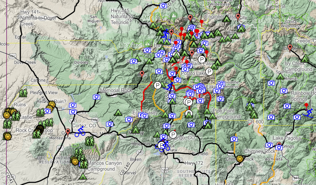
85 Trails
30 Cliff Dwellings
35 Rock Art Panels
80 Scenic Viewpoints
80 Campsites
30 Campgrounds

Towns
Cortez
Mancos
Durango
Bayfield
Pagosa Springs
Creed
Silverton
Ouray
Ridgeway
Telluride
Dolores

National Parks
Mesa Verde

National Monuments
Chimney Rock

National Forests
San Juan
Rio Grande
Uncompahgre