Hiking Dreamspeaker Cave In Sedona, Arizona
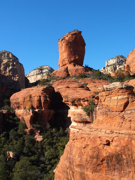
The Boynton Needle is a prominent rock spire that is easily visible from the main system trail in Boynton Canyon. Sitting on the same ledge but NOT visible from the system trail, is a second spire that I call the Dreamspeaker. This is one of the most beautiful spots in all of Sedona, with a massive 360-degree view!

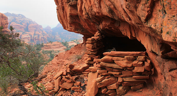
There are at least three spires in this part of Boynton Canyon, which, seen from the right vantage point, resemble human heads. The Dreamspeaker is one of them. It's called the Dreamspeaker because the face of the spire seems to be looking almost directly at a deep alcove in the cliff wall, known as the Dreamspeaker Cave. The alcove contains an impressive cliff dwelling (shown above) from the now extinct Sinagua culture. Experienced hikers can combine a visit to Dreamspeaker Cave with the Subway. Those in excellent physical condition could even include the Women’s Village or the Kachina Tree, creating a big loop that spans both sides of the main system trail.
HIKE DETAILS
RATED: Moderate to difficult due to about 1/4 mile of off-trail route finding.
TOTAL DISTANCE: 6.2 miles out and back
ELEVATION GAIN: 850 ft
EST. HIKING TIME: 3-4 hours round trip from the parking area.
VEHICLE: Any vehicle will do. The parking area for this hike is paved.
BEST TIME TO GO: All year. Start summer hikes by 6 am and finish by 10 am
in order to avoid the heat.
FAMILY FRIENDLY: Maybe. It depends on the age of the children
PET FRIENDLY: No. The terrain here is too rugged for most dogs. Also, please do not visit any ruins with your pet.
TRAILHEAD ENTRANCE
Park at the Boynton Canyon Trailhead. You'll need a Red Rock Pass or an America the Beautiful pass. Or use the free parking on the street if you get there early enough.
GPS for the parking area: 34.90741, -111.84898
GPS for the first critical right turn: 34.92782, -111.86186
GPS for the second critical left turn: 34.93025, -111.86268
GPS for the Dreamspeaker Cave: 34.93270, -111.86918
FINDING THE SOCIAL TRAIL
As the detailed map below indicates, there are at least three ways to reach the Boynton Needle and Dreamspeaker Cave, and four ruins to see once you get up there. The easiest route is a social trail that breaks to the left off the social trail going to the Subway Cave. The other two routes require significant scrambling and a fair amount of brush. The main use of these alternate routes is to make a loop back to the system trail, The longer of these routes has two small granaries to see along the way.
 From the system trail the big ledge all this sits on looks impossible to access, due to the cliffs (shown below).
The backside of the Boynton Needle (shown below) has several obvious breaks in the cliff, where it's possible to get up and down. Find these if you want to make a loop using the longer alternate route.
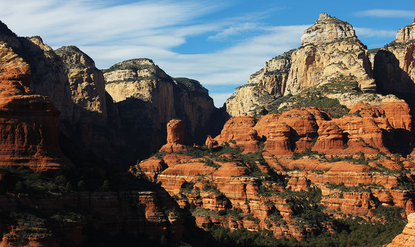
The photo below shows a view of the Boynton Needle (center) and the Dreamspeaker (far right edge of the photo).
There is also a cliff dwelling right at the base of the Boynton Needle (shown below).
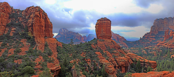
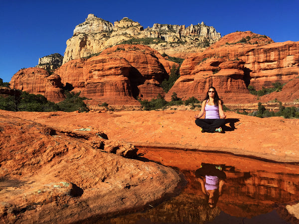
The view from the Dreamspeaker ledge (shown below) is one of my Top 10 favorite panoramas in Sedona. If there has been sufficient rain or snow recently, several water pockets in the rock hold water. This is most likely where the native people who built the ruins got their drinking water. In this photo, the Dreamspeaker Ledge is at the far left.
GETTING BACK HOME - THE ALTERNATE ROUTE
There is no social trail if you go down using one of the alternate routes off the backside of the Boynton Spire, and there are some ledges to navigate. It is also choked with brush, but it does provide a faster route back to the parking area. I have come DOWN this way many times, but I've only gone up twice. A general rule when hiking in canyon country is that going down through brush is easier than coming up.
The always safe alternative is to hike back the way you came, via the Subway social trail.
Download the GPS
Note: The social trail is NOT marked, and navigation can be a little tricky. It's advisable to carry a detailed topographic map or GPS device. You can download the GPS track for this hike by:
1. Click the link below.
2. Select the file type you want.
GPX - best for apps and hand-held devices
JSON - preserves the custom icons
KML - works with Google Earth
3. Click the three little dots at the far right for that file.
Then select DOWNLOAD from the dropdown menu.
4. Import this file to your hiking app or GPS enabled device.
https://drive.google.com/drive/folders/1jYJGY_TVryachcvkPLdKRcAgUrsDqqY6?usp=sharing
The Wanderer's Guide Covers Thousands of Ancient Sites
In the Southwest
There are over 90 stone structures in Boynton Canyon alone! Want to hike more hidden gems like the Dreamspeaker Cave using maps and GPS? Download the Wanderer's Guide to Hiking Sedona! We've logged every turn on the "locals only" secret trails, where you can escape the crowds and find solitude, while hiking with confidence that you won't get lost!