Hiking Subway Cave & Arch Ruin In Sedona, AZ
The Subway is one of the most sought after Instagram images in Sedona. Its location was kept secret by the locals for so long that it is still sometimes referred to online as “Secret Cave”.

The Subway itself faces almost due east, so our famous sunburst photo (above) was captured just after sunrise. As you approach this crack looks completely inaccessible (shown in the photo below, just right of center).

However, once you get closer you’ll find there is a ramp going up the center (shown in the photo below). This ramp is a little bit steep, so you will need good knees and shoes with traction to get up. At the top of this ramp is where the popular photos that originally attracted you to this hike are captured.

Keep walking along the ledge on the right and around the bend you will find a picturesque cliff dwelling (shown below).

If you follow the ledge over to the cliff dwelling you will pass a small bit of Native American rock art (shown in the photo above) along the way.

This is petroglyph of a spiral, stylistically formed into the shape of a turtle. These two symbols have specific meanings in the Pueblo cultures of Arizona and New Mexico. The turtle is a clan symbol and the spiral is a migration symbol.
FINDING THE SOCIAL TRAIL
The main landmark you’re looking for is a large Alligator Juniper with a broken dead branch (shown below). The branch is pointing directly at the social trail leading to the Subway. The tree will be on the left side of the system trail. The social trail on the right will be marked with sticks laid across it.
Look for this landmark tree (shown below) near GPS coordinates 34.927769 -111.861878 and turn right on the social trail when you find it. When you reach the forest service sign announcing that there are archaeological sites in the area, you are almost to the Subway, which will be on your left.

ARCH RUIN
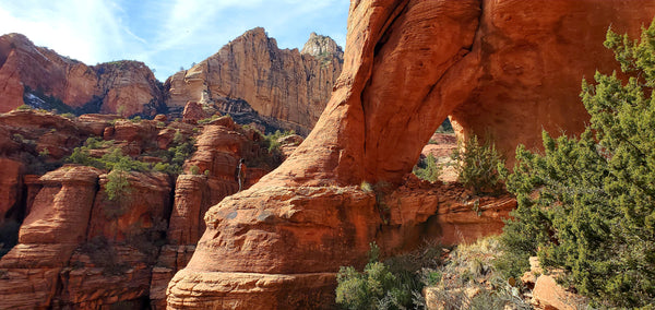
Across the canyon from the Subway is another ruin that is built under an arch. It is easily visible from the Subway, but it looks like a small cave instead of an arch from there. Arch Ruin can be visited by returning to the place where the trail forked to start the climb up to the Subway. Climb up on the little ledge next to the Manzanita and then turn left to proceed around the point and continue up the canyon.
In a short distance there will be a less used social trail that branches to the right and goes downhill. This will take you across the canyon. Go slowly and stay on the trail. You will cross two normally dry stream beds, At the second one you may lose the trail. If so, look downstream and you will see it climbing up a steep bank. The last time I did this hike there was a downed tree across the streambed, so we had to climb over that.

The trail to Arch Ruin is brushy and somewhat difficult to follow, but dwellings built underneath an arch like this are extremely rare in the Southwest, so the short distance makes it worth the extra effort if you're already at the Subway. Adding this side hike to the Subway adds approximately 4/10th mile.

HIKE DETAILS
DIFFICULTY: Easy to moderate with some route finding and scrambling
TOTAL DISTANCE: 5.6 miles round trip
ELEVATION GAIN: 490 feet
BEST TIME TO GO
During the springtime or fall, first thing in the morning or late afternoon after the heat of the day has cooled off.
During the springtime or fall, first thing in the morning or late afternoon after the heat of the day has cooled off.
LOCATION: West Sedona, in Boynton Pass
PET FRIENDLY: No. DO NOT visit archaeological sites with your pet.
PARKING PASS: Required for parking at the trailhead. The Red Rock Pass is $5 per day or $15 for one week. The pass can be purchased at the machine at the trailhead (credit card only). If you have an America the Beautiful Pass, you can use this as well. There is also free overflow parking along the roadside near the intersection of Boynton Canyon Rd and Boynton Pass Rd.
NEARBY HIKES: Fay Canyon, Deadman's Pass, Long Canyon, Bear Mountain, Doe Mountain, Airie Trail, The Cockscomb
DETAIL MAP