Hiking Leprechaun Canyon In Utah

Trail Description
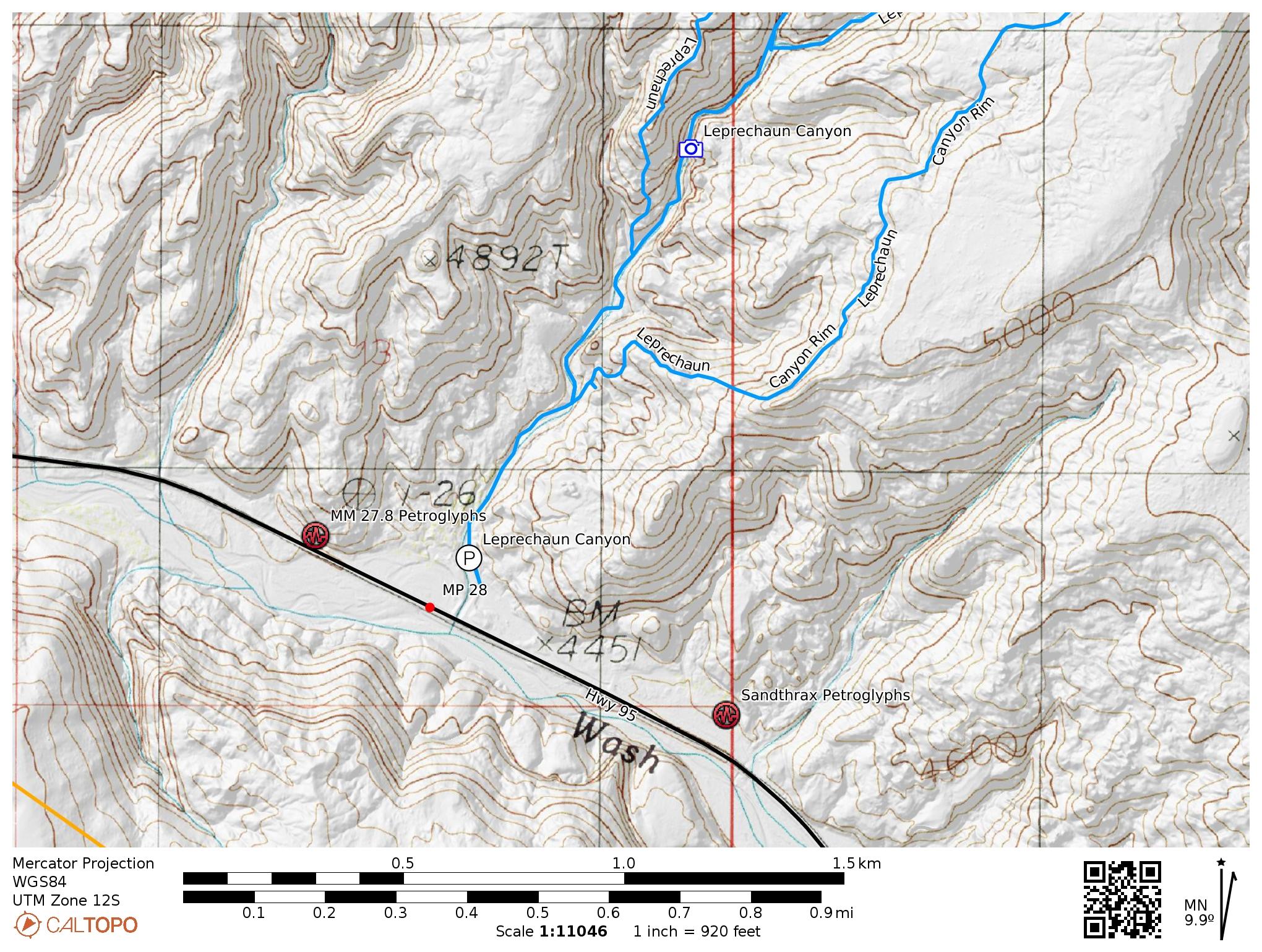
Location: Utah Highway 95, near Hanksville, Utah
Mile Marker: Approximately 28.3
Difficulty: Easy to moderate for the lower canyon, technical for the upper sections
Distance: 1.5 to 3 miles round trip, depending on how far you explore
Family-friendly: Yes, in the non-technical section
Pet-friendly: Yes, but there is some scrambling
Please pick up after your pet and pack it out
Best Season: Spring, fall, and mild winter days
Fee/Permit Required: No
Camping: Dispersed camping is allowed at the parking area and nearby BLM land
From the parking area, follow a sandy wash upstream (north) for about 0.25 miles to reach the entrance of Leprechaun Canyon. The canyon quickly narrows into a classic Utah slot, with towering sandstone walls that close in around you.
The lower section is easy to explore and family-friendly, though it does involve some minor scrambling over rocks and dryfall obstacles. The section shown below is one such area. Most people can easily scramble around this on the right side.

Important: Some tight sections may require squeezing through narrow gaps. Claustrophobic hikers should proceed with caution.
The walls soon narrow dramatically into a dark, shoulder-width corridor — one of the most photogenic sections of the slot. The constricted passages here feature beautifully sculpted Navajo Sandstone and occasional patches of reflected light that create excellent photo opportunities.

After about 0.75 miles, you’ll reach a point where the canyon splits and becomes significantly more difficult. The upper portions of Leprechaun Canyon involve technical obstacles, including deep potholes, high stemming moves, rappels, and narrow passages barely wide enough to fit through. This area is only suitable for experienced canyoneers with proper gear and route knowledge.
How to Get There
From Hanksville, Utah, head south on Utah Highway 95 for 28.3 miles. Look for a large dirt parking area on the south side of the highway near a cattle guard, between mile markers 28 and 29 (precisely around 28.3). There’s a brown BLM sign indicating Leprechaun Canyon. The trailhead is unmarked but well-established, with visible footpaths leading from the parking area toward the canyon’s mouth.
Canyoneering Note
The upper canyon system consists of several branches (locally nicknamed Left Fork, Middle Fork, and Right Fork of Leprechaun Canyon) and has become a popular spot for technical canyoneering. Rappels can reach up to 30 feet, and many sections involve challenging narrows and keeper potholes.
Do not attempt the upper canyon without proper gear, experience, and a weather forecast check. Flash flooding is a serious risk in North Wash canyons.
Camping Information
Dispersed camping is permitted on BLM land near the parking area and along North Wash. The dirt parking lot at the Leprechaun Canyon trailhead doubles as a popular primitive camping spot for hikers and canyoneers. No facilities are available, so come prepared with your own water, waste disposal system, and Leave No Trace practices.
Campers often use this area as a base for exploring nearby slot canyons such as Shillelagh, Sandthrax, and Hog Canyons.
Tips for Visiting
-
Best time to hike: Early morning or late afternoon for cooler temperatures and beautiful lighting inside the slot.
-
Avoid during rainstorms or if rain is forecasted. Slot canyons are extremely dangerous during flash floods.
-
Wear sturdy footwear with good grip for navigating sand, slickrock, and rocky sections.
-
Bring a headlamp or flashlight if you plan to explore the narrowest sections — some areas get quite dark even in midday.
-
Cell service is unreliable in this area. Download maps and information ahead of time.
Nearby Attractions
-
Hog Canyons: A cluster of technical slot canyons a short distance to the west.
-
The Moki Queen Pictograph: This famous image is one of the more mysterious examples of Southwest rock art.
-
Shillelagh Canyon: A similar slot canyon, with a non-technical section in the lower end and a technical section in the upper.
-
Hite Overlook: Spectacular views of the Colorado River and Lake Powell, about 40 miles southeast on Highway 95.
Detail Map
As the map below indicates, there are two ancient rock art panels near the entrance to Leprechaun Canyon.