Jim Thompson
GET THE GPS TRACK FOR EVERY TRAIL IN SEDONA INCLUDED WHEN YOU PURCHASE THE WANDERER'S GUIDE!
Jim Thompson is a system trail in the Coconino National Forest. Designated as Trail #124, it is well marked with signs and easy to follow. This trail can be hiked from either the Wilson Mountain Trailhead (Midgely Bridge) or the Jim Thompson Trailhead (Jordan Rd in Uptown Sedona). From Midgley Bridge parking area, start along the road past the picnic ramada. At 0.1 miles, bear right onto the trail marked by large rock cairns. It gradually climbs, then descends to the canyon drainage.
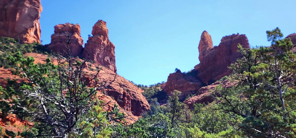
At 0.6 miles, pass the fork signed for Wilson Mountain Trail and 100 yards further, take the left fork signed for Jim Thompson Trail. It immediately begins a 0.2 mile moderate climb. Bear right as you top out and after 100 yards, take the left fork (to the right is a path onto Steamboat Rock). The trail is wide and nearly flat with sparse shade as it follows an old road along the base of Steamboat Rock and past Steamboat Tank on the right at 1.5 miles. Nice views. Parking specifically for vehicles pulling horse trailers is provided at the Jim Thompson trailhead, but behind a locked gate. Please contact the Red Rock Ranger Station for the current combination at 928-203-2900.

FINDING THE TRAILHEADS
A Red Rock Pass or America the Beautiful Pass is require to park in either of the locations described below.
Midgley Bridge: from Uptown Sedona take Hwy 89A north toward Oak Creek Canyon and Flagstaff. 1 mile past the last roundabout in Uptown cross Midgley Bridge and park in the designated parking area on the left side of the highway. A Red Rock Pass or America the Beautiful Pass is required to park here.
GET THE GPS TRACK FOR EVERY TRAIL IN SEDONA INCLUDED WHEN YOU PURCHASE THE WANDERER"S GUIDE!
Jim Thompson: from Uptown Sedona take Jordan Rd to the end and turn left on W Park Ridge Dr. Follow that to the Forest Service parking area at the end of the road. The Jim Thompson Trailhead is at the back of this parking area on the right side.
HIKE DETAILS
4.8 miles out and back
540 ft
3 hours round trip
Sep-Apr. Hike early in the day to avoid summer heat.
PET FRIENDLY
Yes. Must be leashed at all times. Please pick up after your pet and pack it out.